RFS: WRONG PURCHASED INSTEAD OF DJI MATRICE 4 THERMAL
Key Features
3-Axis Gimbal with Multicamera System
20MP Wide-Angle Camera
48MP Medium Tele & Telephoto Camera
Up to 1.1-Mile Laser Rangefinder
Four Intelligent Flight Modes
Low-Light Flying with Night Scene Mode
Multidirectional Surveying/Mapping
O4 Transmission up to 15.5 Miles
Open Developer Support
Detailed Description
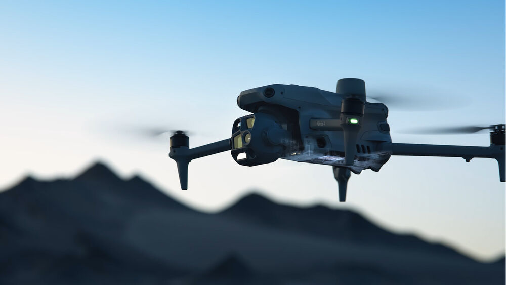
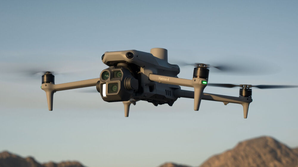
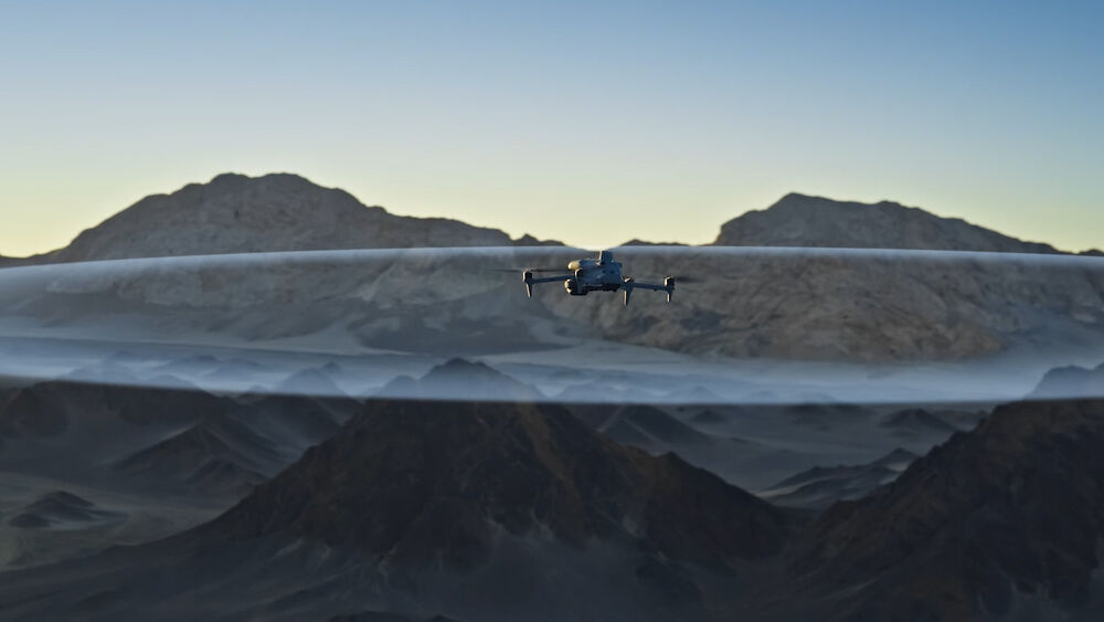
Surveying, mapping, and construction are just a few of the enterprise industries in which the DJI Matrice 4E Drone is designed to excel. At the core of the drone’s abilities is a three-camera system with a laser rangefinder. Specifically, the system is made up of wide-angle, medium telephoto, and standard telephoto lenses. As it flies, a variety of smart features make piloting easier with robust subject tracking and automated flight. In addition to standard drone operation, the large apertures, full-color night vision, and more help to make the Matrice 4E an ideal solution for low-light and night flying. Whatever the mission, omnidirectional obstacle avoidance and other features ensure safe, worry-free operation.
Multicamera System
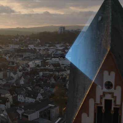
Imaging, mapping, 3D modeling, and more can be done by the multicamera system that’s part of the Matrice 4E’s 3-axis gimbal. You get 20MP wide-angle, 48MP medium telephoto, and 48MP telephoto lenses with up to 112x hybrid zoom (16x optical).
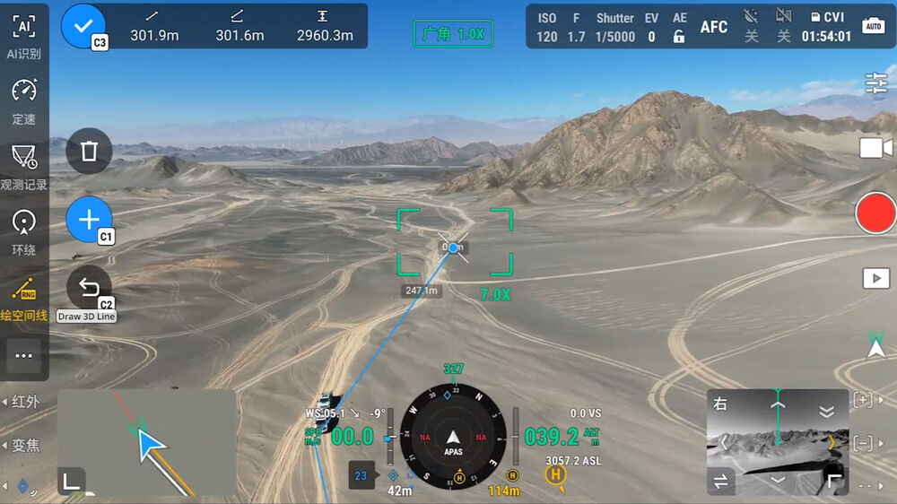
Laser Rangefinder
With a range of up to 1.1 miles, the integrated laser rangefinder is a useful tool for measuring the distance between the drone and specific objects and calculating an entire area. Distant objects can be measured via pinpoint or line drawing, while area calculation utilizes observation range recording. Using the DJI Pilot 2 software, the center of the camera frame is highlighted, along with observed areas. This can help to see which areas have already been covered during a search. These precise measurements are done in real time and can be shared with other personnel for collaboration using a DJI Pilot QR code or through DJI FlightHub 2.
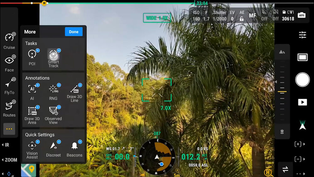
Intelligent Flight Modes
Cruise: This mode makes it easier to fly over long distances. Like the cruise control in your car, set this to have the drone fly forward without having to press on the control sticks.
FlyTo: Specify a location, and the Matrice 4E will automatically adjust its flight path and speed to reach the target.
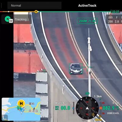
Smart Track: Switch between precisely tracking multiple subjects with automatic zoom to keep them in frame. Subjects can even be reacquired if briefly obscured.
POI: Select a point of interest to have the Matrice 4E fly around while continuously observing and 3D modeling buildings in the area.
Surveying
The Matrice 4E is ideally suited for enterprise surveying and mapping operations. The wide-angle lens can capture images in rapid 0.5-second intervals, using orthophoto and oblique modes to accurately map an area, all while flying up to 47 mph. Under 3-directional orthophoto capture, lateral image capture is done while performing ortho-collection tasks to reduce lateral overlap. This allows for mapping of an area of up to 1.08 sq miles. Under 5-directional oblique capture, the gimbal intelligently rotates to shoot at multiple angles based on the area size. This makes a single flight much more efficient. Additional features and reporting further help to optimize surveying and model mapping.
Smart 3D Capture: Capture and create rough models of structures right on the remote controller screen. From this, more precise mapping routes can be created to get closer and capture more detail. This feature will also display virtual routers and waypoint photos to assess flight safety and the coverage area.
Distortion Correction 2.0: The wide-angle camera is factory calibrated to work with DJI Terra for accurate model reconstruction. This feature delivers precise in-camera distortion correction, leaving residual distortion of less than two pixels.
Auto-Generated Surveying Operation Report: Use DJI Pilot 2 to automatically generate a survey quality report after a mission. You’ll get key information, such as photo points, RTK status, and photo parameters. With this immediate information, you can address any anomaly on the same trip by taking additional photos.
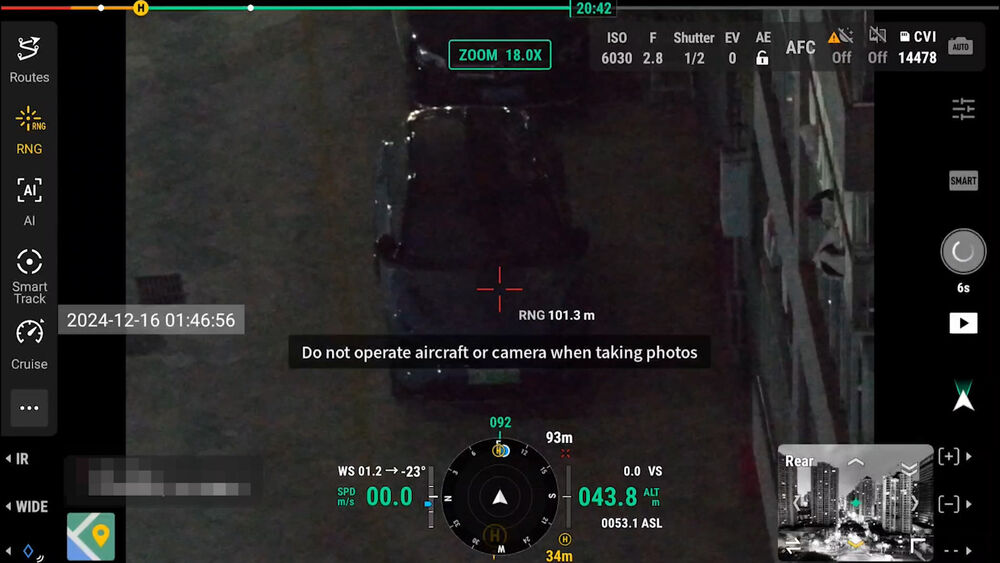
Low-Light Flying
For certain enterprise missions, such as search and rescue, locating subjects from dusk to night can be difficult. This is why the Matrice 4E’s camera system has large apertures to improve low-light imaging, in addition to DJI’s Night Scene mode. Equipped with an IR Cut filter, this mode provides full-color night vision with three modes and two levels of noise reduction to boost quality even further. As you fly, six HD low-light fisheye vision sensors provide automatic obstacle avoidance, intelligent rerouting, and safe returns to home to maximize mission success.
Long-Range Transmission
Using the included RC Plus 2 remote controller, drone control and live video feed can be sent successfully from up to 15.5 miles away. This is due to the O4 Enterprise transmission system, the Matrice 4E’s 8-antenna system, and RC Plus 2’s high-gain antenna. This system even supports fast image transfer with download speeds of up to 20 MB/s.
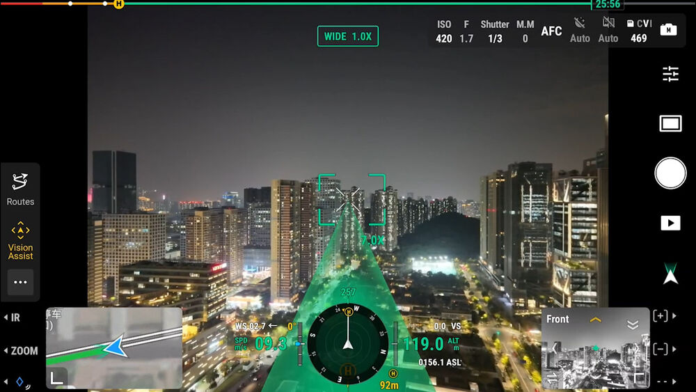
Safe and Worry-Free Flight
An integrated RTK module supports the extended L5 frequency band, which works with GNSS and DJI’s Vision Fusion Positioning and Navigation System to safely return the Matrice 4E home using visual positioning updates. This 5-directional vision assist system and downward vision sensor also allow for rapid takeoff within 15 seconds and return to home in areas lacking a GNSS signal.
On top of the return-to-home feature is general obstacle avoidance. Use the Matrice 4E’s map-based guidance feature to enhance that by connecting the RC Plus 2 Enterprise remote to the internet. With that connection, you can load terrain elevation and area maps to help with more precise avoidance and automatic route planning. An excellent feature for flying at night or in mountainous regions.
Software Support
Matrice 4E is made to work with DJI Pilot 2, FlightHub 2, Terra, and Modify. These applications provide piloting, route planning, mapping, 3D modeling, sharing, and much more.
Open Development
Institutions, organizations, and agencies can have very specific needs when it comes to drone usage. This is why DJI allows the Matrice 4E to support open development. Developers can enhance the drone’s capabilities using Intelligent Algorithm Developer, PSDK, MSDK, Cloud API, and DJI Terra API.
Data Security
Enterprise-level drones can be involved with highly sensitive data acquisition, which is why DJI offers Local Data Mode, the ability to clear all data with a single tap, AES-256 video transmission encryption, and Cloud API to keep information secure.
DJI Matrice 4E Specs
Maximum Flight Time
49 Minutes
Remote ID
Yes
Camera System
Wide
20 MP, 4/3″-Type CMOS Sensor with 24mm-Equivalent, f/2.8 Lens (84° FoV) Medium Telephoto
48 MP, 1/1.3″-Type CMOS Sensor with 70mm-Equivalent, f/2.8 Lens (35° FoV) Telephoto
48 MP, 1/1.5″-Type CMOS Sensor with 168mm-Equivalent, f/2.8 Lens (15° FoV)
Maximum Video Resolution
All Cameras
Up to UHD 4K at 30 fps
Still Image Support
Wide
Up to 20.8 MP (DNG / JPEG / Raw) Medium Telephoto
Up to 48.7 MP (JPEG) Telephoto
Up to 50.3 MP (JPEG)
Sensing System
Omnidirectional with Infrared/LiDAR Enhancement
Control Method
Included Transmitter
Weight
2.7 lb / 1219 g (With Propellers, Battery)
3.1 lb / 1420 g (with Maximum Payload)
Performance
Maximum Horizontal Speed
47 mph / 75.6 km/h
Maximum Ascent Speed
22.4 mph / 36.0 km/h
Maximum Descent Speed
17.9 mph / 28.8 km/h
Maximum Wind Resistance
26.8 mph / 43.1 km/h
Maximum Take-Off Altitude
3.7 Miles / 6 km
Maximum Flight Time
49 Minutes
Maximum Hover Time
42 Minutes
Maximum Tilt Angle
35°
Hovering Accuracy
Vision Positioning
±0.3′ / 0.1 m RTK
±0.3′ / 0.1 m GNSS
±1.6′ / 0.5 m
Aircraft
Rotor Configuration
Quadcopter
Propeller Size
10.8″
Remote ID
Yes
Aircraft I/O
1x USB-C (Data)
1x E-Port (Expansion)
Operating Conditions
14 to 104°F / -10 to 40°C
Imaging
Number of Cameras
4 (Cannot Be Used Simultaneously)
Camera System
Wide
20 MP, 4/3″-Type CMOS Sensor with 24mm-Equivalent, f/2.8 Lens (84° FoV) Medium Telephoto
48 MP, 1/1.3″-Type CMOS Sensor with 70mm-Equivalent, f/2.8 Lens (35° FoV) Telephoto
48 MP, 1/1.5″-Type CMOS Sensor with 168mm-Equivalent, f/2.8 Lens (15° FoV)
Zoom
112x Optical
Minimum Focus Distance
Wide
3.3′ / 1 m Medium Telephoto
9.8′ / 3 m Telephoto
9.8′ / 3 m
ISO Sensitivity Range
Wide
100 to 25,600 (Extended: 100 to 204,800) Medium Telephoto
100 to 25,600 (Extended: 100 to 409,600) Telephoto
100 to 25,600 (Extended: 100 to 409,600)
Night Vision
No
Shutter Speed
Wide
Electronic Shutter: 1/8000 to 2 Seconds (Photo/Video)
Mechanical Shutter: 1/2000 to 2 Seconds (Photo/Video) Medium Telephoto
1/8000 to 2 Seconds (Photo/Video) Telephoto
1/8000 to 2 Seconds (Photo/Video)
Maximum Video Resolution
All Cameras
Up to UHD 4K at 30 fps
Still Image Support
Wide
Up to 20.8 MP (DNG / JPEG / Raw) Medium Telephoto
Up to 48.7 MP (JPEG) Telephoto
Up to 50.3 MP (JPEG)
Photo Modes
Interval, Single Shot
Media/Memory Card Slot
In Aircraft Body
microSD/microSDHC/microSDXC In Remote/Transmitter
SD/SDHC/SDXC
Internal Storage
In Remote/Transmitter
128 GB
Gimbal
Number of Axes
Three: Pitch (Tilt) / Roll / Yaw (Pan)
Rotation Range
Controllable Range
Pitch (Tilt): 125° (-90 to 35°) Mechanical Range
Yaw (Pan): 130° (-65 to 65°)
Roll: 104° (-52 to 52°)
Pitch (Tilt): 190° (-140 to 50°)
Follow Speed
Tilt: 100°/s
Stabilization Accuracy
±0.007°
Avoidance/Sensing System
Sensing System
Omnidirectional with Infrared/LiDAR Enhancement
Sensing System Capabilities
Forward
Measurement Range: 1.3 to 656.2′ / 0.4 to 200 m
Max Speed: 47 mph / 75.6 km/h
Field of View: 90° (Horizontal) / 135° (Vertical) Backward
Measurement Range: 1.3 to 656.2′ / 0.4 to 200 m
Max Speed: 47 mph / 75.6 km/h
Field of View: 90° (Horizontal) / 135° (Vertical) Lateral
Measurement Range: 1.6 to 656.2′ / 0.5 to 200 m
Max Speed: 47 mph / 75.6 km/h
Field of View: 90° (Vertical) / 90° (Horizontal) Downward
Measurement Range: 1.0 to 61.7′ / 0.3 to 18.8 m
Max Speed: 22.4 mph / 36 km/h
Field of View: 160° (Front-to-Back) / 160° (Side-to-Side)
Remote Controller / Transmitter
Control Method
Included Transmitter
Transmission System
OcuSync 4.0 (OC4)
Frequencies: 2.4 GHz (2.4 to 2.4835) / 5.1 GHz (5.15 to 5.25) / 5.8 GHz (5.725 to 5.85)
Power at 2.4G: 33 dBm (FCC) / 20 dBm (CE/MIC/SRRC)
Power at 5.1G: 23 dBm (CE/FCC)
Power at 5.8G: 33 dBm (FCC) / 30 dBm (SRRC) / 14 dBm (CE) Wi-Fi 6 (802.11ax)
Frequencies: 2.4 GHz (2.4 to 2.4835) / 5.1 GHz (5.15 to 5.25) / 5.8 GHz (5.725 to 5.85)
Power at 2.4G: 26 dBm (FCC) / 20 dBm (CE/MIC/SRRC)
Power at 5.1G: 23 dBm (FCC)
Power at 5.8G: 23 dBm (FCC/SRRC) / 14 dBm (CE) Bluetooth 5.2
Frequencies: 2.4 GHz (2.4 to 2.4835)
Power at 2.4G: 10 dBm
Maximum Operating Distance
15.5 Miles / 25 km
Transmitter I/O
1x USB-C (Power)
1x HDMI (Video)
1x USB-A (Data)
Clean Video Output
No
Battery Type
Built-In Lithium-Ion (6500 mAh)
Operating Temperature
-4 to 122°F / -20 to 50°C
Mobile App Compatible
No
Built-In Display
7.02″ (1920 x 1200) Touchscreen LCD, 1400 nits/ cd/m2
Dimensions
10.6 x 6.4 x 3.7″ / 268 x 163 x 94.5 mm
Flight Battery
Battery Chemistry
Lithium-Ion
Battery Capacity
6741 mAh / 99.5 Wh
Battery Configuration
4 S / 14.76 V
Maximum Charging Power
17 V
Charging Temperature
41 to 104°F / 5 to 40°C
Weight
14.1 oz / 401 g
Charger
Input Power
100 to 240 VAC, 50 / 60 Hz at 2.5 A
Output Voltage
17 V
Power Rating
100 W
General
GNSS Support
GPS, GLONASS, BeiDou, Galileo
Diagonal Size
17.3″ / 438.8 mm
Overall Dimensions
10.3 x 5.4 x 4.5″ / 260.6 x 138.4 x 113.7 mm (Folded)
15.3 x 12.1 x 5.9″ / 387.5 x 307.0 x 149.5 mm (Unfolded)
Weight
2.7 lb / 1219 g (With Propellers, Battery)
3.1 lb / 1420 g (with Maximum Payload)
![DJI Matrice 4E Drone [BRAND NEW]](https://storage.googleapis.com/prg-photo-shop-bucket/2026/01/MATRICE-4E-A.jpg)
![DJI Matrice 4E Drone [BRAND NEW] - Image 2](https://storage.googleapis.com/prg-photo-shop-bucket/2026/01/MATRICE-4E-B.jpg)
![DJI Matrice 4E Drone [BRAND NEW] - Image 3](https://storage.googleapis.com/prg-photo-shop-bucket/2026/01/MATRICE-4E-C.jpg)
![DJI Matrice 4E Drone [BRAND NEW] - Image 4](https://storage.googleapis.com/prg-photo-shop-bucket/2026/01/MATRICE-4E-D.jpg)
![DJI Matrice 4E Drone [BRAND NEW] - Image 5](https://storage.googleapis.com/prg-photo-shop-bucket/2026/01/MATRICE-4E-E.jpg)
![DJI Matrice 4E Drone [BRAND NEW] - Image 6](https://storage.googleapis.com/prg-photo-shop-bucket/2026/01/MATRICE-4E-F.jpg)
![DJI Matrice 4E Drone [BRAND NEW] - Image 7](https://storage.googleapis.com/prg-photo-shop-bucket/2026/01/MATRICE-4E-G.jpg)
![DJI Matrice 4E Drone [BRAND NEW] - Image 8](https://storage.googleapis.com/prg-photo-shop-bucket/2026/01/MATRICE-4E-H.jpg)
![DJI Matrice 4E Drone [BRAND NEW] - Image 9](https://storage.googleapis.com/prg-photo-shop-bucket/2026/01/MATRICE-4E-I.jpg)
![DJI Matrice 4E Drone [BRAND NEW] - Image 10](https://storage.googleapis.com/prg-photo-shop-bucket/2026/01/MATRICE-4E-J.jpg)
![DJI Matrice 4E Drone [BRAND NEW] - Image 11](https://storage.googleapis.com/prg-photo-shop-bucket/2026/01/MATRICE-4E-K.jpg)
![DJI Matrice 4E Drone [BRAND NEW] - Image 12](https://storage.googleapis.com/prg-photo-shop-bucket/2026/01/MATRICE-4E-L.jpg)
![DJI Matrice 4E Drone [BRAND NEW] - Image 13](https://storage.googleapis.com/prg-photo-shop-bucket/2026/01/MATRICE-4E-M.jpg)
![DJI Matrice 4E Drone [BRAND NEW] - Image 14](https://storage.googleapis.com/prg-photo-shop-bucket/2026/01/MATRICE-4E-N.jpg)